Unveiling the Earth's Secrets with Microtremor Surveys
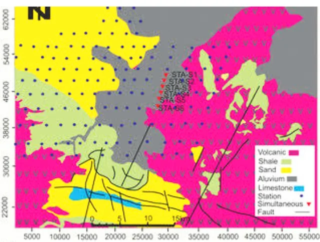
A microtremor survey is a geophysical technique that uses the Earth's natural vibrations, called microtremors, to reveal information about the subsurface.
Unlike traditional seismic surveys that create vibrations with thumpers or explosives, microtremors are constantly present due to ambient sources like traffic, machinery, ocean waves, and even wind.
By measuring these subtle tremors with seismometers and analyzing them with sophisticated techniques, scientists can extract valuable details about the underlying soil and rock.
Have you ever wondered what lies beneath the surface of our planet? Microtremor survey technology offers a powerful tool for geologists, engineers, and anyone curious about the hidden layers of the Earth
Microtremor Survey Technologies
| Technology | Description | Applications |
|---|---|---|
| Microtremor Array | A network of sensors placed strategically to capture tremors from various directions. | Provides detailed information on subsurface variations, ideal for earthquake engineering and geohazard mitigation. |
| Spectral Analysis of Surface Waves (SASW) | Analyzes the frequency content of microtremors to determine shear-wave velocity profiles. | Standard method for microtremor surveys, used in earthquake engineering, resource exploration, and general subsurface characterization. |
| Horizontal to Vertical Spectral Ratio (HVSR) | Compares the strength of horizontal and vertical components of tremors to estimate fundamental resonance frequency of the site. | Rapid and cost-effective method for assessing earthquake site vulnerability, particularly for soft soil conditions. |
Note: This table presents a simplified overview. Additional microtremor survey technologies and variations of these methods exist.
Listening to the Earth:
Unlike traditional seismic surveys that use man-made vibrations, microtremor surveys harness the Earth's natural whispers. These subtle tremors come from ambient sources like traffic, machinery, ocean waves, and even the wind. By strategically placing sensors and analyzing these tremors, scientists can extract valuable information about the subsurface.
Unveiling the Layers:
Microtremor surveys excel at revealing the shear-wave velocity profile of the Earth. This profile essentially tells us how quickly vibrations travel through different layers of soil and rock. This information is crucial for:
- Earthquake Engineering: By understanding the subsurface structure, engineers can assess a site's vulnerability to earthquake shaking. Areas with soft, loose soil tend to amplify tremors, posing a greater risk.
- Resource Exploration: Microtremors can aid in locating potential sources of oil, gas, and geothermal energy by identifying changes in subsurface density.
- Geohazard Mitigation: Unearthing buried faults or unstable geological formations can help prevent landslides and other disasters.
Advantages of Microtremors:
- Non-intrusive: Unlike drilling or trenching, microtremor surveys are a non-destructive way to probe the subsurface. This makes them cost-effective and environmentally friendly.
- Rapid Deployment: The equipment is portable and requires minimal setup, allowing for quick surveys across large areas.
- Detailed Insights: Microtremors provide high-resolution data on shallow subsurface layers, which can be missed by other methods.
Looking to the Future:
Microtremor survey technology is constantly evolving. Advancements in data processing and interpretation techniques are allowing scientists to extract even more detailed information from these ever-present tremors. As the technology matures, expect microtremor surveys to play an increasingly important role in various fields, from ensuring safe construction practices to unlocking the Earth's hidden treasures.
Unveiling Leaders Country in Microtremor Survey Technologies
Pinpointing a single leading country in microtremor survey technologies is difficult. Research and development efforts are spread across various nations, each contributing advancements to this field. However, several countries stand out for their significant contributions:
Leaders Country in Microtremor Survey Technologies
While singling out specific companies is challenging due to ongoing research at universities and government institutions, here's a table highlighting leading countries and some notable companies involved in microtremor survey technology development and applications:
| Country | Notable Companies | Areas of Expertise |
|---|---|---|
| Japan | Kinemetrics Inc. (US subsidiary), Kyoshin Mechatronics Co., Ltd. | Sensor development, SASW method development |
| United States | Geometrics, Inc., Incorporated Research Institutions for Seismology (IRIS) | Sensor technology, Data analysis & interpretation methods |
| Italy | Geostudi Ascoli S.r.l., University of Florence | HVSR technique refinement, Software development |
| France | ISTerre (French National Research Institute), GEOTER Ingénierie | Geohazard mitigation applications, Advanced data processing techniques |
| China | Institute of Geophysics, Chinese Academy of Sciences (IGCAS), BGI Company Limited | New applications of microtremor data, Sensor development |
Important Note:
- This table presents a simplified overview, focusing on a few prominent examples. Numerous other companies worldwide contribute to microtremor survey technologies.
- The areas of expertise listed are not exhaustive and may not represent the full range of a company's activities.
-
Japan: A pioneer in microtremor research, Japan has made significant strides in data processing and interpretation techniques. They played a crucial role in developing the Spectral Analysis of Surface Waves (SASW) method, a standard tool in microtremor surveys.
-
United States: The US also boasts a strong presence in microtremor research. American researchers have contributed to advancements in data analysis methods and broadening the applications of microtremor surveys.
-
Italy: Italian researchers have been instrumental in refining the Horizontal to Vertical Spectral Ratio (HVSR) technique, a rapid and cost-effective method for earthquake hazard assessment.
-
France: French research institutions actively contribute to developing microtremor survey technologies and their applications, particularly in geohazard mitigation.
-
China: With increasing focus on earthquake safety and resource exploration, China has seen a surge in microtremor research activities. Chinese researchers are actively developing new applications and interpretations of microtremor data.
A Global Endeavor:
It's important to acknowledge that research and development in microtremor survey technologies is a global endeavor. New technologies and methodologies are constantly emerging from various countries around the globe. International collaboration plays a key role in advancing this field and improving our understanding of the Earth's subsurface.
Frequently Asked Questions About Microtremor Surveys
Microtremor surveys are a geophysical method used to estimate the dynamic properties of the subsurface, such as shear wave velocity and natural frequency. This information is essential for various applications, including earthquake engineering, geotechnical engineering, and site characterization.
Basic Concepts
- What are microtremors?
- Microtremors are continuous, low-amplitude vibrations caused by various sources, such as traffic, wind, and distant earthquakes.
- How do microtremor surveys work?
- Microtremor surveys involve recording the ground motion caused by microtremors using seismometers. The recorded data is then analyzed to determine the dynamic properties of the subsurface.
Applications of Microtremor Surveys
- What are the main applications of microtremor surveys?
- Microtremor surveys are used in a wide range of applications, including:
- Earthquake engineering: Assessing site amplification and liquefaction potential.
- Geotechnical engineering: Evaluating subsurface conditions for construction projects.
- Site characterization: Determining the dynamic properties of the subsurface for various purposes.
- Geophysical exploration: Identifying geological structures and faults.
- Microtremor surveys are used in a wide range of applications, including:
- How are microtremor surveys used in earthquake engineering?
- Microtremor surveys can be used to estimate site amplification, which is the process by which seismic waves are amplified by the subsurface. This information is essential for designing earthquake-resistant structures.
Challenges and Limitations
- What are the challenges of conducting microtremor surveys?
- Challenges include:
- Noise: Noise from various sources can interfere with microtremor measurements.
- Data analysis: Analyzing microtremor data can be complex and requires specialized software.
- Site conditions: Site conditions, such as topography and vegetation, can affect the quality of microtremor measurements.
- Challenges include:
- What are the limitations of microtremor surveys?
- Microtremor surveys are limited to shallow depths and may not be suitable for areas with complex subsurface structures.
Future Directions
- What are the future directions of microtremor surveys?
- Future directions include:
- Development of new data analysis techniques: Developing more advanced data analysis techniques for microtremor surveys.
- Integration with other geophysical methods: Combining microtremor surveys with other geophysical methods, such as seismic refraction and electrical resistivity tomography.
- Automation: Developing automated microtremor survey systems to improve efficiency and reduce costs.
- Future directions include:


